Showing posts with label lake. Show all posts

Tuesday, July 29, 2014

Birthday Weekend!

So I admittedly didn't do any hiking this weekend. I did have a very enjoyable time camping for my close friends birthday though!

Here are a few silly photos:


Matt enjoying the water.


We went to Blanchard lake which is South of Seeley Lake, MT by about 20 minutes. 2 hours and 20ish minutes from where I live.


Mr. Pike, caught by none other than the birthday boy himself! And he was yummy. <--- the pike I mean


Ron, my very talented pup... falling asleep suspended in mid air. How does he do it?! What would you call that a zzzuper power?


More silly antics! Ron is clearly not in to it all, or maybe he just wanted a butt photo? Either way I would say, mission accomplished.


Ron, self-appointed cooler guard.


Catching some waves, the Ron dog is so cool he even floats right along with us. Of course all we really caught were fish and moss but it sure was a blast!


Wooh for a fun weekend... until next time, happy trails and wiggly tails!

Tuesday, July 8, 2014

Crater Lake

Today we set off on a bit of a longer endeavor than last time... a 12 mile trek to Crater Lake. This hike begins at the main Jewel Basin Trail head which is pretty heavily trafficked and then technically goes out of the Jewel. 


We got started on an old road so it was very wide open, there were patches of snow here and there.


About a mile in you'll come up to where the trail splits of too several trails. You can head to Mount Aeneas, Picnic Lakes, or just about anywhere in the Jewel Basin for that matter.

This trip was so beautiful that the only way to truly express the trip is visually using photos, so there's gonna be many of them an fewer words.

Just a few miles in you hit a high point where you can gaze into the valley and look down on Martha Lake.


You can easily see straight to the bottom of the lake, it also has a waterfall going in to it but I wasn't able to capture that splendor using my phone... guess you'll have to go see for yourself! 


More patchy snow along the trail... Ron loved snacking on it!


About 3 Miles in now and behold Birch Lake! It's a very large lake and the trail to Crater follows right along the whole shore of it.

Watch out though, use insect repellent on you AND your pet. There are black flies in this area, their bite is very irritating and they can hang on to your pets belly for some time if you don't catch it. Those of you who are also equestrians are likely very familiar with the little buggers.


With the summer being very mellow up to this point in the year, there was still plenty of snow on the way there! It required a lot of exhausting side hilling in the snow and to be perfectly honest, it got pretty old after the 3rd or 4th mile of it!


We did end up losing the trail at a couple of points due to all the snow, it was nearly impossible to tell where it was. We climbed some rocks and looked out over beautiful views though!
We found a spot for lunch!


Trail food... it always tastes so good because after all the work you're starving!


Overall the trail isn't very difficult, there's no really significant elevation change and I'm sure that without the snow it would have been pretty mellow... If you do happen to go at a time when there is snow make sure to have ice cleats and trekking poles at the very least or I really wouldn't recommend it. It was not easy!


There were several points after Birch that we were able to see the trail, most of it was washed out from all the snow melt.


There was a waterfall by Squaw Lake coming right across the trail. Refreshing as well as visually pleasing!


 Squaw Lake


Did I mention all the snow?!

We're about 5 miles in now, a storm hit and the rain was coming down so we took shelter in some trees to let it pass... Ron was looking a little tired at this point so we decided it was time for him to take a little  ride!
 
 And off we go!


There's a short descend to the lake on a pretty small trail with all kinds of rocks and brush.
To see the full album from this trip click here.


The lake was even better than I'd imagined! There was almost no snow in the area surrounding it.
Trail conquered!

You can follow my blog, "like" my FB page or just leave me a lovely comment if you please. 

Until next time, Happy Trails!

Sunday, June 29, 2014

Strawberry Lake Redo

This particular Sunday the weather was predicted to be 60's and rainy.... the day fulfilled those predictions to the tee. We made the decision to head out anyway and go for a smaller, easy trail. Strawberry Lake fit the bill... of course we thought the weather would deter other hikers and we may have the trail primarily to ourselves. Well, sure called that wrong.  The trail head was completely full, 8 or more vehicles including two horse trailers and we managed to run into every single one. 

It was a great mix of groups including families, dirt bikers and a pack train. The first portion of the trail, which is about a mile, is a decent elevation gain with many switch backs.
 At one point a small pack train and some dirt bikers crossed paths... It could have been a less than ideal scenario. In this case tension was little high on the horses (and mules) part but thankfully the equestrians were experienced and the dirt biker were considerate.

As we made it to the point in the trail where we hit piles of snow last time we tried it, it looked like a completely different trail!


The rest of the trip was very mellow and the trail is easy. There's just a small dip that brings you down to the lake.
The lake is stunning, we walked up a bit of the trail that leads to Wildcat lake in order to get a view.
The trail onward was full of very slushy snow and we decided to turn back, Strawberry lake was our goal anyway.
DISTANCE 6.73 mi

ELEVATION GAIN 2700 ft

TOTAL TIME 03:22:23
AVERAGE SPEED 3.71 mph


MOVING TIME 01:48:41

MAX SPEED 8.57 mph
 This is an ideal trail for a novice/beginner hiker or someone with children.
 
Until next time! 
Happy trails and Happy Fourth of July!


Monday, June 23, 2014

Cedar Lake - Swan Valley

6/23/14
Our first back country hike of the season! We were so excited as we scoped out our hike online using topographic maps and trail descriptions. So after some discussion Cedar Lake was decided on, an intermediate 7 mile hike.

Interestingly enough we ended up driving right past our turn, if course there's not even a glimpse of cell phone service down there. Fatty Creek Road is in no way marked from the highway and very easily passed but if you look hard enough you can see a bear warning sign a little ways down the road. From there it doesn't get much better as far as road signage goes, there's no sign until you get a around 6 miles in. Here it finally says FSR 10182 which promptly turns right and becomes FSR 10381, follow that all the way up and you hit the trail head.


The trail gets a little adventurous early on with a creek to wade and then some cliffs.


We ended up having to carry our little dog across the creek, he's our newly adopted French Bulldog! 

After about 1.5-2 miles of the trek in you come upon a no name lake, it's a cute lake and the trail took us right down by the shore of it so we could get a good view.


Continuing on we immediately met consistent snow... quickly turning in to very deep snow. Luckily the snow pack was hard enough that we were able to hike over it with ease... so long as we paid close attention not to step on any pockets. The trail was lost but only 1.5-2 miles of forest and mountain was between us and our coveted destination, Cedar Lake. We must keep going!


 Some rest was taken to ensure our smaller companions health and make him more comfortable. We also took time to snack on our power bars, jerky and trail mix which is an essential part of any hike! 


He even took a short nap. Now back on the trail...
We looked for a low point in the ridge in front of us an were greeted by a view when we hit the top. So close to the lake now! You can see it as soon as you hit the top although it's still a deceiving distance away.

We found our way down the other side of the mountain and straight to the tip of a rock cliff, while the view was gorgeous we did have to back track a small amount to make it closer to the actual lake shore.

It's still pretty early in the season for these back country hikes so the lake was rather high, not easily accessible and still encased by a ring of ice. Of course this makes it all the more pleasing to look at!

 For the panoramic view of the lake I would highly suggest following this link to get a better look. - Click Here -

However, here is a small glimpse:
 And one more photo of the splendor before I wrap up this trail expedition!

It is like that this trail would be considered intermediate but due to the amount of snow and loss of the trail it ended up being an advanced trek. 

DISTANCE 7.15 mi
ELEVATION GAIN 2182 ft
TOTAL TIME 04:58:43
AVERAGE SPEED 3.15 mph
MOVING TIME 02:16:15
MAX SPEED 7.43 mph 

Friday, June 13, 2014

Lincoln Lake - Glacier National Park

Early June we decided to embark on a little more challenging hike, not difficult but a test of endurance. This hike, in to a gorgeous mountain lake in Glacier National Park, starts off pretty strenuous but it mellows out quickly.

Woke up feeling great, got things done and hit the trail at a leisurely 10:30 am. It's a steep, unrelenting grade for the first 1.6 or so miles, you'll definitely want a trekking pole on this venture. I didn't bring one and coming down that slope on the 14th mile of the day was pretty dang rough.


Once you get to the top of the first part it starts looking more like this, there's so much vegetation in between the trees! 


We crossed over a lot of water, little streams and creeks.


Coming down one switchback there was an oh-so tempting log. We just had to walk out on it. Of course at this point we were going down... uh-oh, we thought.


This seems to be a very good hike to do earlier in the season, there was minimal mud even though it had rained the day before and the bugs were not bad at all either. 


About 2 miles in! Yay. The trail splits off and you can hike over to Fish lake if you really wanted to but we were determined to make it in to secluded Lincoln lake. Having been told it was a trail you would only want to back pack it felt like a challenge to make it a day hike.


Along the way we began to see signs of animal activity... including very fresh bear movement. 


The farther you go, the more looming the mountains are, they just seem to get taller and taller!


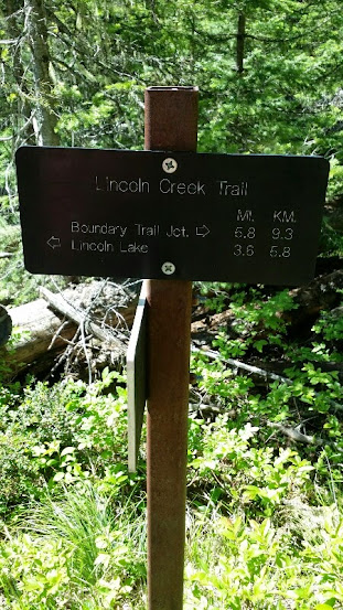
Getting closer, 3.6 miles left according to the sign, now we're starting to get excited! Over half way there.

The scenery on the trail just keeps getting better and better. We saw a few robins eggs along the way.


The rest of the hike was pretty mellow terrain wise.


We made it!
I haven't exactly perfected the surround shot but it's still cool!


The way back was tiring but there was some exciting things too... like this log!